The OTUS Project: Drones Brave Tornado Cores for Unprecedented Scientific Data

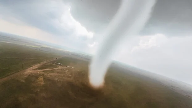
A dedicated team of storm chasers, operating under the banner of the OTUS Project (Observations of Tornadoes by UAV Systems), is pushing the boundaries of meteorological research by deploying camera drones directly into the heart of active tornadoes. This pioneering initiative has successfully completed over a dozen intercepts, culminating in a groundbreaking live stream in June that captured a drone’s penetration into an EF3 tornado for the very first time. The data and imagery gathered from these perilous missions offer a unique, ground-level perspective previously inaccessible to scientists, potentially revolutionizing our understanding of these violent atmospheric phenomena and enhancing public safety.
A New Frontier in Tornado Research
For decades, meteorologists have relied on Doppler radar, storm-penetrating aircraft, and ground-based sensors to study tornadoes. While these methods have provided invaluable insights, they have limitations. Doppler radar can detect wind speeds within a tornado’s circulation but struggles to provide precise surface-level data, especially within the most intense core. Traditional storm-penetrating aircraft, while capable of flying near or within tornado circulations, cannot safely navigate the chaotic and debris-filled inner core where the most critical atmospheric processes occur. Ground-based sensors are often destroyed by the extreme winds and flying debris long before they can transmit comprehensive data from the tornado’s most destructive zones.
The OTUS Project aims to bridge this data gap by utilizing custom-built drones. These unmanned aerial vehicles (UAVs) are designed to withstand the immense forces within a tornado, collecting vital surface-level data such as temperature, moisture content, and wind speed and direction at altitudes and proximity previously thought impossible. This data is crucial for refining weather models, improving tornado forecasting, and ultimately, issuing more accurate and timely warnings to communities in the path of these destructive storms.
The Genesis of the OTUS Project: Innovation Born of Necessity
The development of the OTUS Project’s technology is a testament to ingenuity and perseverance. The drones are not off-the-shelf consumer models; they are purpose-built machines engineered to survive conditions that would obliterate conventional aircraft. Louis Tucker, a celebrated National Collegiate Drone Racing Champion in 2023, serves as the team’s lead builder and pilot. His expertise in high-performance drone design is complemented by Tanner Beard, an engineer who meticulously fabricates custom components using a range of advanced tools in his home workshop, including a mill, a lathe, and a battery of 3D printers.
The airframes themselves are 3D-printed, a technique that allows for lightweight yet incredibly robust construction. Weighing approximately two pounds, these drones are capable of speeds up to 220 miles per hour. This remarkable combination of low weight and high velocity is critical for their ability to penetrate the intense updrafts and turbulent wind shears within a tornado’s core, rather than being immediately thrown off course or destroyed by flying debris. Each drone is equipped with a high-definition GoPro camera, providing breathtaking first-person footage, alongside an array of sophisticated sensors. These sensors meticulously log temperature, humidity, barometric pressure, and three-dimensional wind loads in real-time.
The team operates a fleet of roughly 15 such aircraft, with each drone representing an investment of around $2,500. Tucker estimates that the OTUS Project has personally invested over $25,000 in equipment and development within a single year, highlighting their profound commitment to this scientific endeavor.
A Breakthrough in Wind Sensing
A significant hurdle in developing these drones was the creation of sensors capable of accurately measuring the complex wind dynamics within a tornado. Off-the-shelf sensors were either too heavy, too fragile, or lacked the ability to capture the crucial vertical wind component. In collaboration with the National Institute of Standards and Technology (NIST), Nelson Tucker (presumably a team member or collaborator) developed an innovative omnidirectional wind sensor. This specialized instrument is capable of measuring the tornado’s vertical wind component, a critical piece of information that ground-based instruments simply cannot capture. The lightness of this sensor was paramount, enabling its integration into the small, agile drones.
The flight strategy employed by the OTUS Project is as calculated as the drone construction. Before attempting an intercept, the drones typically orbit the tornado at various altitudes. This allows the team to assess the storm’s behavior, identify safe entry points, and gather contextual data. As the tornado’s structure becomes clearer and conditions permit, the drones progressively tighten their orbits, inching closer until they can successfully penetrate the vortex. This deliberate approach maximizes data collection while minimizing risk to the drone and the mission’s objectives.
The Science Behind the Spectacle
While the visual spectacle of a drone flying into a tornado is undeniably captivating, the primary motivation behind the OTUS Project is rooted in rigorous scientific inquiry and a commitment to public safety. The data gathered from within the tornado’s core is invaluable for several reasons:
- Improved Weather Models: High-resolution, in-situ data on temperature, pressure, and wind profiles can significantly enhance the accuracy and predictive power of meteorological models. These models are the backbone of modern weather forecasting, and even small improvements in their input data can lead to more reliable predictions.
- Enhanced Warning Systems: A deeper understanding of how tornadoes form, intensify, and dissipate, particularly within their inner core, can lead to more precise and earlier warnings. This could translate into precious extra minutes for residents to seek shelter, potentially saving lives and reducing injuries.
- Understanding Tornado Dynamics: Scientists are still unraveling the complex physics of tornado formation and behavior. Data from inside the vortex can provide direct observations of phenomena such as the formation of secondary vortices, the role of debris in the storm’s structure, and the exact mechanisms of extreme wind generation.
- Infrastructure Resilience: Understanding the precise forces exerted by tornadoes on the ground can inform building codes and infrastructure design, leading to more resilient structures that can better withstand extreme weather events.
The live-streamed penetration of an EF3 tornado in June represents a significant milestone. An EF3 tornado, according to the Enhanced Fujita scale, possesses wind speeds between 136 and 165 miles per hour, capable of causing severe damage, including lifting vehicles and tearing roofs off well-constructed homes. Capturing data from within such a powerful storm is a testament to the robustness of the OTUS Project’s technology and the team’s daring approach.
Broader Implications and Future Prospects
The success of the OTUS Project has far-reaching implications beyond immediate tornado research. It showcases the burgeoning capabilities of small, agile drones in extreme environments. For industries ranging from disaster response and infrastructure inspection to agricultural monitoring and environmental science, the ability to deploy robust, sensor-laden drones into previously inaccessible or dangerous locations opens up a new era of data collection and operational efficiency.
The imagery captured, such as the first-person view from the Arnett, Oklahoma intercept (available for viewing via the embedded YouTube link), offers a visceral and awe-inspiring perspective of nature’s power. This visual documentation not only educates the public about the intensity of tornadoes but also underscores the bravery and dedication of the individuals involved in this cutting-edge research.
While the OTUS Project is currently self-funded and driven by passion, the potential for collaboration with governmental agencies, academic institutions, and private meteorological organizations is immense. As the technology matures and further validation is achieved, the data gathered by these intrepid drones could become an indispensable tool in the global effort to understand and mitigate the impacts of severe weather. The team’s commitment to pushing the envelope of drone technology and scientific exploration serves as an inspiration, demonstrating how innovation, coupled with courage, can unlock unprecedented insights into the most formidable forces of nature. The journey from a small crew’s ambitious idea to live-streaming a drone’s journey into the heart of a tornado is a powerful narrative of human ingenuity confronting the raw power of the atmosphere.